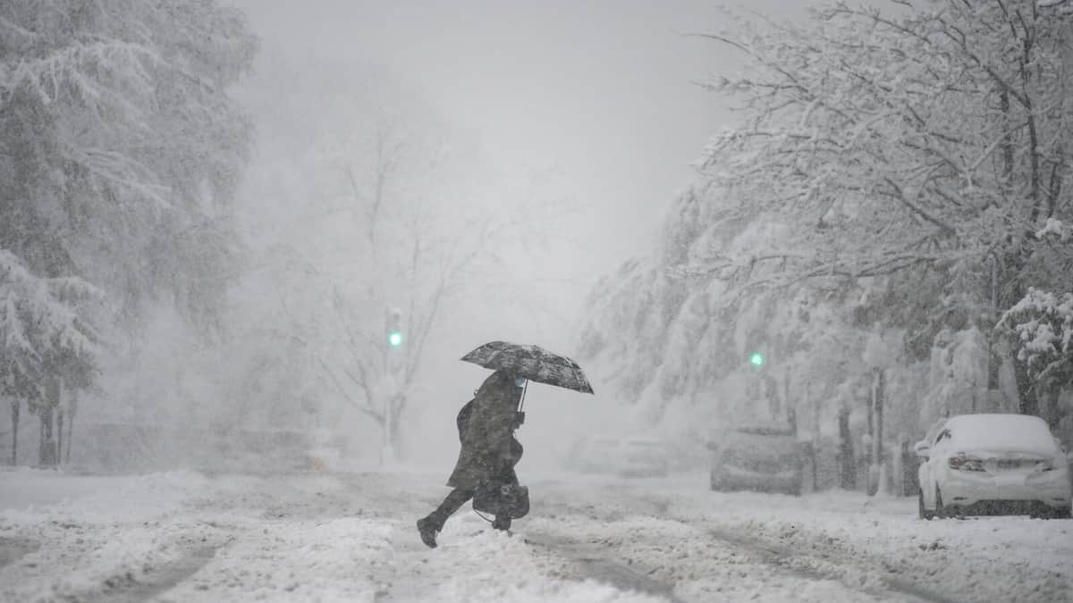
A major winter storm sweeping the US this week may bring the coldest Christmas in four decades to parts of the country, say forecasters. The “once-in-a-generation” cold snap - which began in the Pacific Northwest on Tuesday, before churning east - will become a “bomb cyclone” by Friday.
About 80% of the nation is set to experience sub-zero temperatures, including places as far south as Texas. More than 90 million people are under winter weather alerts across 37 states. Named Winter Storm Elliot by the Weather Channel, the arctic blast is expected to deliver the coldest Christmas to the Midwest since the late 1980s, according to forecasts cited by US media.
The National Weather Service (NWS) said bone-chilling temperatures of -50F (-45C) and -70F were possible by the end of this week in some parts of the country. “Wind chills of this magnitude can cause frostbite in less than five minutes if precautions are not taken, with hypothermia and death also possible from prolonged exposure to the cold,” said its advisory. The NWS has called it a once-in-a-generation winter weather event, especially as the storm reaches the Great Lakes region, where its pressure is expected to reach the equivalent of a Category 3 hurricane. As the storm develops, meteorologists anticipate it will turn into a “bomb cyclone”.
What is a bomb cyclone?
Bomb cyclone is a term given to a storm that intensifies rapidly, with its central air pressure dropping by at least 24 millibars in 24 hours. They are referred to as bomb cyclones due to the explosive power caused by the rapid fall in pressure. Such storms bring weather ranging from blizzards to severe thunderstorms to heavy precipitation. Bomb cyclones are most common on the east coast of the US and Canada, where the cool land and warm Gulf Stream current provide optimal conditions.
The National Weather Service said: "Heavy snowfall rates will spread northward across NH [New Hampshire] and through southern/central ME [Maine] through early this evening.
“In addition to heavy snowfall rates, the intensifying storm will result in strengthening winds, producing blizzard conditions for coastal regions of New England.”
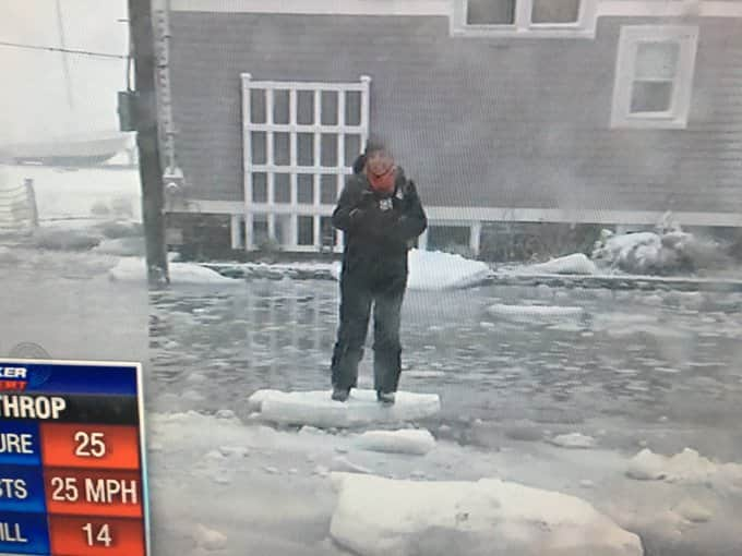
In Boston, weather officials say the tide may reach its highest recorded level since 1921.
Coastal flooding has already begun in some areas of Massachusetts, and weather forecasters warn that it may takes days for water to drain back into the ocean.
The National Weather Service has warned residents to not stand on icebergs as they float down city streets.
I heard the -50 degrees on the tv earlier but wasn’t sure whether it’s centigrade or farenheit. Still not sure from the above how cold it will be there in centigrade but I thought it was -50c.
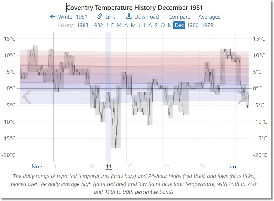
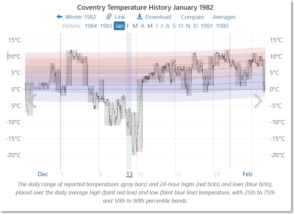
To put those temperatures in perspective for me, the coldest that I recall being was probably in 1981:
The winter of 1981–1982 in the United Kingdom (also called The Big Snow of 1982 by the press) was a severe cold wave that was formed in early December 1981 and lasted until mid-late January in 1982, and was one of the coldest Decembers recorded in the United Kingdom.
The Central England Temperature region (CET) recorded a daily mean temperature of 0.3 °C (32.5 °F) and a daily minimum temperature of −2.7 °C (27.1 °F), for December, the coldest December recorded in the 20th Century. The CET region also reported its coldest minimum December temperature at −15.9 °C (3.4 °F) on the 13th. The coldest temperature recorded in December was −25.2 °C (−13.4 °F) recorded in Shawbury, Shropshire on the 13th, and is the coldest December temperature recorded in England. Wales also recorded its coldest recorded December temperature during the cold wave, with a temperature of −22.7 °C (−8.9 °F) recorded at Corwen, Denbighshire also on the 13th.
The coldest temperature recorded in the United Kingdom during the cold wave was recorded in Scotland with a temperature of −27.2 °C (−17.0 °F) recorded in Braemar, Aberdeenshire on 10 January, and is the coldest temperature ever recorded in the United Kingdom. England also recorded its coldest temperature during the cold wave at −26.1 °C (−15.0 °F) which was recorded at Newport, Telford and Wrekin, also on 10 January.
I have very fond memories of the big freeze of 81. Drinking hot chocolate and enjoying being set free from school hours earlier than expected. The roads were like an arctic tundra.
I had to dig the deep snowdrift away from the up and over garage door with my bare hands to get the car out to go to work…The shovel was also in the garage…
The eldest is living in Banff Alberta, on Thursday it was -37 with wind chill making it feel -45, its not warmed up to normal of -16 overnight and - 6 during the day.
It may seem counterintuitive, but more snowfall during snowstorms is an expected effect of climate change. That’s because a warmer planet is evaporating more water into the atmosphere. That added moisture means more precipitation in the form of heavy snowfall or downpours.
During warmer months, this can cause record-breaking floods. But during the winter – when our part of the world is tipped away from the sun – temperatures drop, and instead of downpours we can get massive winter storms.
Scientists predict climate change could make blizzards more intense. A warmer atmosphere holds more moisture. This moisture eventually falls as precipitation—either as rain (when temperatures are warm) or snow (when temperatures are below freezing)—which results in more frequent and intense storms. Sea temperatures are also on the rise, which increases the amount of energy and moisture available to storms, thus amplifying their severity.
On average, winters are getting warmer and shorter, with fewer places experiencing extremely cold temperatures. However, because the warmer atmosphere holds more moisture, blizzards are more likely to occur and be more severe in places where temperatures are still cold enough for snow.
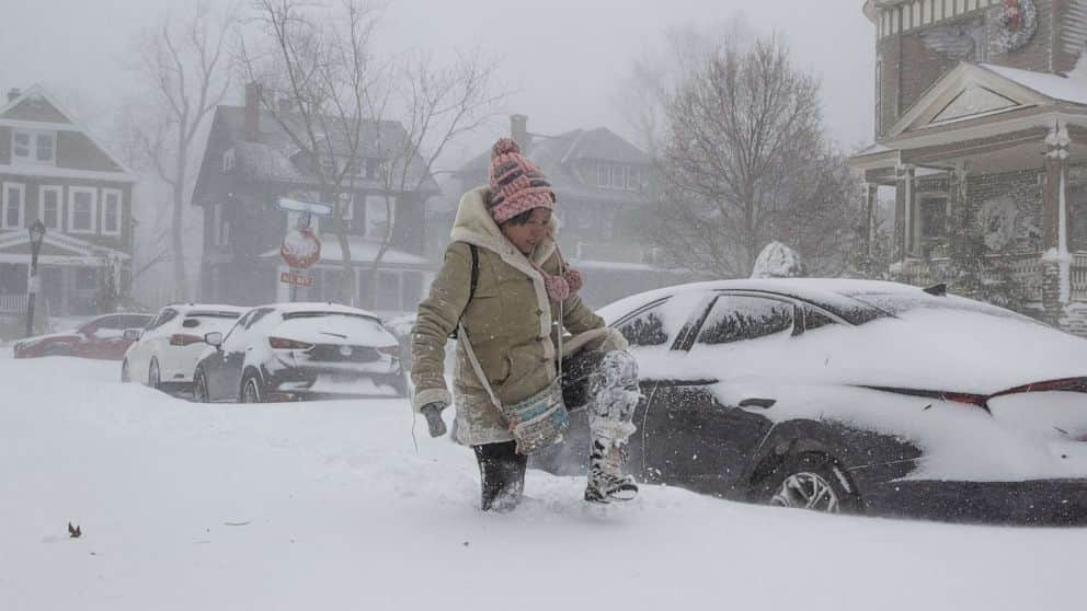
Jessica Chan of Buffalo, New York, navigates deep snow as a large winter storm, continues to hit Buffalo, Dec. 24 2022.
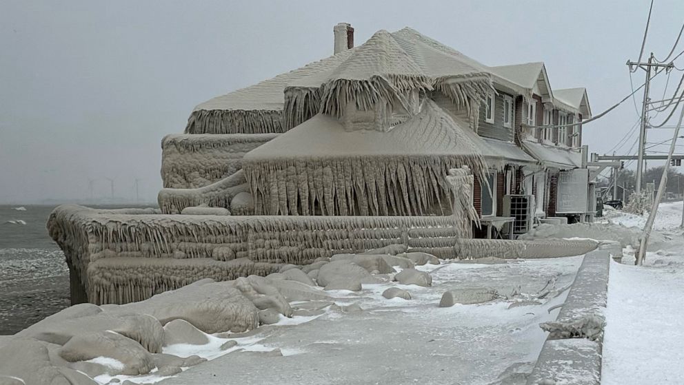
Hoak’s restaurant is covered in ice from the spray of Lake Erie waves during a winter storm that hit the Buffalo region, Dec. 24, 2022 in Hamburg, New York.
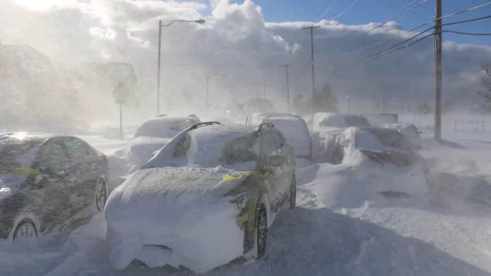
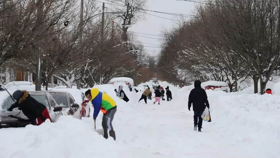
John Silver shovels snow between buried cars in front of his home on Third Street in South Boston
At least 28 people have died in western New York state, most of them in Buffalo, as a monster winter storm continues to batter North America. Up to nine more inches (23cm) of snow are expected in parts of the state on Tuesday, meteorologists warn.
A state official said some people had been trapped in cars for more than two days during what was “probably” the worst storm of their lifetime.
Many emergency vehicles had been unable to reach worst-hit areas or had got stuck in snow themselves. More victims are expected to be discovered once melting snowdrifts reveal trapped vehicles and allow access to remote homes.
At least 34 people have died in Erie County, which includes the city of Buffalo, county executive Mark Poloncarz said on Wednesday.
Authorities are still trying to identify three of the victims.
There have now been more fatalities in Erie County in the last few days than during the infamous Buffalo blizzard of 1977. Twenty-nine people died in that storm, according to the National Weather Service.
But conditions in some of the hardest-hit regions in the US - including New York - are starting to improve.